Project Blog

<< First  < Prev   1   2   Next >  Last >> 
  • 17 Jul 2013 11:42 AM | Deleted user

    Thanks so much to all of you who attended the wetland forum last Wednesday and/or assisted with the preparation for that event.  It was another great success, with over 50 people in attendance (some pictures below).  At this event, we again made several contacts with landowners interested in protecting their land and with folks in professions who can utilize the model data in their work.  I was thrilled to connect with a realtor who is interested in the model data to flag potential conservation properties (and encourage landowner participation/listing in our conservation buyer program) as she goes about her work!  I believe our NRCS folks also generated interest in WRP from several folks in attendance.


    A special thank you to Love Creek Nature Center for hosting us- what a great site for the event!  And also to Matt Meersman, Frank Velazquez and Alex Bozymowski, our speakers for the evening.  We had really good questions and a pretty good appetizer spread for those of us who forgot to eat dinner. These outreach events will go such a long way in helping us connect with priority landowners so that we can protect more critical land and water resources in the St. Joseph River Watershed!


    Sincerely,


    Geoff Cripe

    FotSJR Board Member


  • 23 May 2013 5:45 PM | Deleted user

    Salameander: Of Wetland Restoration, Climate Adaptation, and Local Watershed Solutions

    Click here to read the full blog, or view the summary below.

    It is exciting to hear about a tangible example of the application of wetland strategies to address local issues and goals. Here is one recently showcased on an ASWM webinar presentation by Matt Meersman of Friends of the St. Joe River.

    Friends of the St. Joe is a non-profit group dedicated to improving habitat, water quality, and overall management of the St. Joseph River -  which wanders through agricultural and urban areas of Michigan and Indiana before reaching Lake Michigan.  This is a story about how far-sighted folks at “Friends” have teamed with the Southwest Michigan Planning Commission, the Michigan Department of Environmental Quality (MDEQ), and a number of other partners to tackle one important local issue using wetland mapping and assessment methods, an understanding of wetland ecological services, and good local communication.

    Here are the background facts:

    • Great Lakes water levels are currently near all-time lows.The Great Lakes fluctuate on a long term (multi-decade) cycle, and most – although not all – models predict further long term decline in response to climate change.
    • MDEQ has been working for some time to map wetlands on a watershed basis using the U.S. Fish and Wildlife Service –National Wetland Inventory Plus/LLWW landscape level assessment method.  (See link at end of blog post.)  The result portrays not only wetland location, but general functions and ecosystem services based on wetland type, hydrology, and landscape position.  And, by comparing historic and current wetland maps, one can also evaluate loss of wetland function, as well as potential sites for restoration of function.
    • The St. Joseph River watershed has lost 53% of the wetland area that existed prior to European settlement, and about 49% of sediment retention function provided by pre-settlement wetlands.
    • A significant amount of existing and potentially restorable wetland – and associated sediment retention function – is located on large parcels of land. The opportunity for successful preservation or restoration may be greatest when working with a limited number of large landowners. These landowners can include state and local government agencies, farms, businesses, individuals, and conservation groups.
    • Given modern sediment loads, frequent and extensive harbor dredging is needed to maintain many river mouth areas for both commercial and recreational boat traffic.  Current low water levels have exacerbated this impact.  Cessation of dredging would have a devastating impact for commercial barge traffic.  In February, Michigan Gov. Rick Snyder proposed expenditure of $11 million in 2013 to dredge Michigan harbors that are in danger of losing their connections to open water because of low Great Lakes levels.

    Putting it all together:

    • Planners from Friends of the St. Joe, local units of government, and the regional planning commission understand that restoration of wetlands in targeted watershed areas will increase sediment retention – providing an improvement in water quality in the St. Joe River, and over time reducing the amount of sediment that needs to be dredged to maintain the harbor.  Wetland preservation will also help to maintain sediment retention levels.  Using LLWW maps to show specific areas where this approach may be effective, resource planners have piqued the interest of the St. Joseph River Harbor Authority according to Matt Meersman, who has led the wetland partnership project.  Discussions are underway regarding the potential to utilize a portion of funds available for dredging proactively to reduce sediment loads at the source through wetland restoration.  Partners are continuing to analyze the extent of possible benefits in greater detail.  Preliminary discussions are also underway with other harbors in the area.
    • Local resource managers are, of course, pursuing multiple goals for the St. Joseph watershed, and using the LLWW data to help plan and set priorities.  Wetland restoration for one purpose will typically help to address others, including wildlife habitat, water quality, biodiversity, floodplain management, and recreation.  All of which adds up to a potential win-win-win situation.
    • The financial and technical support of state and federal agencies, combined with the innovation and land use know-how of multiple local partners adds up to a no-regrets approach to wetland and watershed management.  Regardless of the actual future impact of climate change on Great Lakes water levels and stormwater/runoff patterns, increased sediment retention and decreased dredging will provide both economic benefits for the shipping industry, and protection of public resources.

    Friends of the St. Joe and their partners are currently looking in greater detail at the potential extent of sediment retention and likelihood of success. You can view Matt Meersman’s full PowerPoint presentation (audio to be added soon) here.

    More information on the Friends of the St. Joe – Wetland Partnership Project is here.

    A U.S. Fish and Wildlife Service Fact Sheet on the LLWW methodology used by the DEQ is described here:

    The MDEQ wetlands program can be found here.

    This is but one example of problem solving using National Wetland Inventory Plus maps combined with state and local know how to address a wide range of resource management issues.  We look forward to hearing about many similar reports as we think through climate change issues.

  • 19 May 2013 6:05 PM | Deleted user

    Well into its third year, the Wetland Partnership Project is drawing notice from the EPA and Association of State Wetland Managers (ASWM). Recently, Matt Meersman, President of the Friends of the St. Joe River, had to opportunity to share what has been learned for the Wetland Partnership Project relative to the St. Joseph River Watershed.

    On May 19, 2013, Matt co-presented with Jeanne Christie, Executive Director: Association of State Wetland Managers at the National River Rally conference. Together, they presented on the topic "Understanding and Leveraging State Wetland Programs". State Wetland Programs can be sorted into four major areas of activity: regulatory programs, water quality standards for wetlands, restoration programs and monitoring and assessment programs. Regulatory programs involve issuing or conditioning permits and related activities such as mitigation (replacement of wetlands). Water quality standards for wetlands are the development of standards that provide a framework for wetland regulation. Wetland restoration programs are voluntary programs to restore lost or degraded wetlands. Monitoring and assessment programs evaluate wetland health and can provide the scientific basis for the other three types of wetland programs. The Association of State Wetland Managers works closely with states and interested tribes to support development of comprehensive wetland programs that include all four major areas.

    On May 21, 2013, Matt had the opportunity to present once again with Jeanne Christie at an EPA/ASWM sponsored webinar in celebration of American Wetlands Month. Their four-part presentaiton  "State and Regional Wetland Restoration Strategies" can be viewed below:

    Part 1: http://vimeo.com/67315802

    Part 2: http://vimeo.com/67315803

    Part 3: http://vimeo.com/67318378

    Part 4: http://vimeo.com/67320328

    Matt also gave a presentation to the Middle Grand River Watershed steering committee is interested in doing a similar project and asked Matt to speak to them about ours.

  • 14 May 2013 6:32 PM | Deleted user

    Local Businesses and Organizations Unveil Educational Signs for American Wetlands Month

    The Van Buren Conservation District put the finishing touches on the Paw Paw and Black Rivers Wetland Project just in time to celebrate American Wetlands Month.  Five educational signs were recently installed throughout the Harbor Shores golf course and public trail system in Benton Harbor.  The signs were the result of a partnership between the Conservation District, Harbor Shores, Revolution Design and WYNN Waterjet & CNC Machining, all of which donated generous amounts of time and money to complete the project.

    This May is the 23rd anniversary of American Wetlands Month, which provides an opportunity to celebrate the vital importance of wetlands to the Nation's health.  Wetlands occur where land and water meet. They clean our water, prevent floods and provide wildlife habitat.  Acre for acre, wetlands offer more water quality benefits and produce more wildlife and plants than any other Michigan habitat type.

    “Unfortunately, about 50% of the wetlands in southwest Michigan have been filled for development or drained for agriculture in the last 200 years.  We have been working with landowners, municipalities and other partners over the last 3 years to protect what is left and bring back some of what has been lost,” said Matt Meersman of the Van Buren Conservation District.  The wetland project has resulted in the permanent protection of over 400 acres of high priority wetland and the restoration of almost 70 acres of wetland.

    The installation of the wetland signs is one of the most visible and long lasting of the many educational efforts that took place during the project.  Robert Piner created the sign panels, which are displayed on metal cattail sculptures designed by Jim Steinke and built by Dan Mitowski.  Each one presents a different message about wetlands and clean water that is connected to the landscape surrounding the sign.  According to Bob McFeeter of Harbor Shores, “the signs have an important message and their location offers the viewer an example of what the sign is about.”

    The Van Buren Conservation District promotes the conservation of natural resources through partnerships by providing public education, demonstrations and technical assistance, while working together for future generations.

    For more information on this topic, or to schedule an interview with one of the partners, please call Matt Meersman at (269) 657-4030 xt.115 or email Matt at paddleheadz@gmail.com or visit:

    http://vanburencd.org/programs-services/watershed-projects.
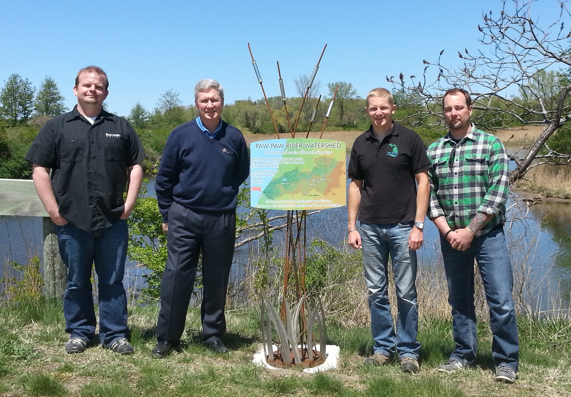
    Photo Included: Project partners in front of wetland sign.
    From left to right - Robert Piner, Bob McFeeter, Matt Meersman, Jim Steinke

  • 25 Apr 2013 11:31 AM | Deleted user

    Today marked the 10th quarterly meeting for the Wetland Partnership project. Click here for a summary of the meeting. A meeting was held in the Prairie River Watershed with about 25 people in attendance. Rachel Smith compiled a mailing list using data from the wetland assessment. Matt had a computer set up so that landowners could actually see maps of their properties and the wetlands on each parcel. Some discussion was held concerning the Watershed Management Plan that will be developed by LaGrange County SWCD for the Fawn River and how the wetland assessments can be used to enhance the final plan. Joe Schmees encouraged the SWCD to make sure that critical wetland areas for preservation be listed in the plan.

    Matt reported that the 9th quarterly report has been submitted to EPA. If the current timeline is followed, there are just two more quarters remaining in the grant, which would end in September. There is still money left in the grant possibly to do some additional outreach events. Matt talked with EPA and they sounded optimistic that an extension could be given on the grant. Matt sent an official request for a one year extension, which would allow for more time to use the remaining funds.

    There was some additional discussion about the Prairie River Watershed wetland event. Rachel Smith sent out a post card, not a formal letter, as invitations to the meeting. Rachel did a couple of interviews promoting the meeting and the wetland project and there were some publicity articles in local newspapers. Four landowners, each owning at least 40 acres of land, were interested in knowing more about ways they can protect the wetlands on their properties. It was a successful event.

    Geoff Cripe is working to hold three more outreach meetings this summer and fall. He is working with a committee in Cass and St. Joseph Counties. One meeting will be scheduled in the Dowagiac River Watershed/Berrien and Cass Counties.

    Marcy Colclough did a presentation at the Calhoun County Conservation District’s Annual Meeting. Marcy has two meetings scheduled next week with local planning officials to begin discussing ways to use this wetland information in new planning ordinances, etc. One meeting will be held in Paw Paw, Michigan on Tuesday, April 30 and the other is scheduled for Thursday, May 2 in South Bend. The purpose of the meetings is to introduce the planning experts to the wetland project and discuss the strategy to use throughout the watershed. Some of the questions include where to hold future meetings; land use throughout the watershed; what options are available for protection and what are gaps that local units can fill with state regulations.

    NEXT STEPS:

    • Having the data on line so that individuals and municipalities can access the information is crucial to the success of this project. The tables are available on line now without any explanation, but it will leave most people scratching their heads.
    • Establish next landowner meetings – Geoff Cripe
    • Continue with the municipal outreach strategy and bus tour

    Our next meeting will be held on Thursday, August 22 2013 at 10:15 a.m. in the Three Rivers Public Library.

  • 20 Dec 2012 8:22 PM | Deleted user

    Today marked the 9th quarterly meeting for the Wetland Partnership project. Click here for a summary of the meeting. Matt announced that the Friends held another successful outreach event on November 7 at the Howe School in Howe, Indiana. This was the third official outreach event of the Wetland Partnership Grant, counting one in Branch County, Michigan, and one along Christiana Creek in Elkhart, Indiana. Matt explained that the wetland prioritization tool was used to develop a list of landowners that owned the most highly functioning wetlands for either protection or restoration in the local Fawn and Pigeon River watersheds. There was an approximate return of 7 to 10 percent of landowners that received letters in attendance at the event, with a total near 45 attendees including Friends and other Partnership members. Matt spoke at the event about the Partnership project and the important functions of wetlands. The local SWCDs gave a presentation on projects being completed in the area as well. Wood-Land-Lakes RC & D and U.S. Fish and Wildlife Service were on hand to talk to landowners about potential wetland restoration/protection projects. Scott Fetters mentioned that he is already working with 3 landowners from that night on wetland projects. He has two landowners in LaGrange County and one in Steuben County, with the largest project near 100 acres.

    Matt and Marcy had a recent meeting with Jeremy and Chad from Michigan DEQ to discuss the wetland prioritization tool and the final deliverable product. They were able to give them the final, merged parcel data. Matt and Marcy expressed that they felt it was a productive meeting, and that Michigan DEQ is excited about the prioritization methodology developed through the Wetland Partnership Project.

    Matt announced an upcoming event that is not associated with the Wetland Partnership Grant, but is similar in scope. He explained that through the Van Buren County CD 319 grant they are hosting two events on January 31, to discuss wetland functions in the Black and Paw Paw River watersheds. They will be held at Sarett Nature Center in Benton Harbor from 3 – 5 PM, and at Lake Michigan College in South Haven from 7-9 p.m. Matt explained that the meeting locations were designed to be at the downstream end of the respective watersheds.

    Matt stated that the group needed to begin thinking about the next outreach event for the Wetland Partnership Grant. There have been two events on the Indiana side and one on the Michigan side. He discussed that the group would like to target the next Indiana event on the Elkhart River watershed, but there are currently no clear choices for another event in Michigan. Matt also discussed that there are areas in Cass and Van Buren Counties that have had large amounts of wetland loss, and this area might be good for targeted outreach. It was reiterated that the final data from the wetland prioritization model should be taken into account when deciding the next Michigan outreach locations.

    Matt and Marcy gave a presentation to the St. Joe Harbor Authority concerning the wetland prioritization tool. Matt explained that it was a perfect group to target. It was explained that they are concerned with sediment deposition in the harbor, and the tool could potentially indicate wetlands that would be useful for sediment retention in their watershed. Matt and Marcy are also giving a presentation to health departments in the Michiana area tomorrow to discuss pathogen retention potential in local wetlands. Matt also gave a presentation to the St. Joe River Home Owners Association.

    Matt thanked Rachel, Melanie, and Brian for their work in merging the duplicate parcels in ArcGIS for use with the wetland prioritization tool. This work is now complete and was delivered to Michigan DEQ this past week. Matt talked with Michigan DEQ about the final deliverable and what it will be. Other GIS tools have been placed on a read-only CD and work as a standalone program, but Matt explained that the hopes for this project it would be an online tool.

    Our next meeting will be held on Thursday, April 25, 2013 at 10:15 a.m. in the Three Rivers Public Library.

  • 07 Nov 2012 6:24 PM | Deleted user

    The Friends of the St. Joseph River hosted another successful wetland partnership outreach event in Howe, Indiana with about 35 in attendance for a very polished program. A dozen of the attendees came in response to our targeted invite (representing about seven percent of all letter recipients). Most of the attendees came early and stayed after the program to grab handouts, take a run or two at the impressive cheese tray and discuss their interests. Several left with interest in conservation program enrollment. The event was successful due to the collaboration of all our conservation partners that made this happen and many of whom attended in support.

    A huge thanks to our speakers, Martin Franke, Dave Arrington, Matt Meersman, RD Wolheter (landowner) and Jerry Gray (landowner), who kept it very interesting and informative for our attendees. A special thank you to Martin Franke and Kayleen Hart, representing the Lagrange and Steuben Soil and Water Conservation Districts, respectively, Brian Musser who works for NRCS in their Lagrange office who collectively helped to plan and put the program for the evening together. Thanks to Matt Meersman, who booked the venue, spoke and worked behind the scenes in the sound booth to keep everything running. We thank the Howe School who allowed us to use their Bouton Auditorium, a great venue. Additional special recognition to Marcy Colclough who drove all the way to Howe from Benton Harbor (MI) to help set up for the event and take pictures.


  • 23 Aug 2012 6:09 PM | Deleted user

    Today marked the 8th quarterly meeting for the Wetland Partnership project. Click here for a summary of the meeting. Matt Meersman and Marcy Colclough met with Julie Pioch to bring her up-to-date on the project. She will be working under the grant to develop a plan to aid with outreach to government officials about the ways they can use the information being developed through this wetland partnership grant. Julie is in charge of the citizen planner program with MSU Extension. Matt is working with her to develop an agreement/contract between MSUE and FotSJR. Julie stated that after a contract is completed and signed, she will begin developing a strategy to work with units of local government to show how the wetland information can be used in planning. This should take about two months. They will be including an add-on course focusing on wetlands to the MSU 7-week Citizen Planner Course. Julie is gathering information on what to include in the course. Once the lesson is developed the information can be taken to local officials. It will be a challenge to get Indiana planners involved since there is such a huge difference in local government structures from Michigan.

    The parcel data is over 50 percent complete for the entire watershed. Matt, Eric, Brian, Melanie and Rachel are merging the parcel data by county.

    The "Wet and Wild at the Well Field" was a great event held last week in the Christiana Creek Watershed. One hundred letters were sent out to key individuals owning wetlands classified as being good for water quality. Five of the people who received letters attended the event, with three of them being some of the top 10 landowners in their respective watersheds. At least one of them requested that someone follow-up and provide more information about the wetlands on their property.

    Another upcoming event will focus on the Elkhart River watershed with a focus on restoration. Eighty percent of the wetlands in this watershed have been lost. An attempt will be made to find landowners who have enrolled land in WRP through NRCS to provide a testimonial at this event. Geoff will provide information about the tax incentives available through the Land Conservancy.

    Regarding Outreach strategies, efforts can be piggy-backed with other events, but there will be several more events specifically targeting the wetland project. Geoff and Matt will be doing 15 minute presentations at some of these other events. One of the next events will be in the Steuben/LaGrange area of the Pigeon River/Fawn River Watersheds. Southwest Michigan Land Conservancy has agreed to help with 6 events with 3 in Indiana and 3 in Michigan – 2 focusing on protection and 1 with restoration. The other event in Indiana will most likely be the Elkhart River Watershed.

    Our next meeting will be held on Thursday, December 20 at 10:15 a.m. in the Three Rivers Public Library.

  • 16 Aug 2012 9:51 PM | Deleted user

    The wetland partners held their second outreach event, “Wet N’ Wild at the Wellfield”, today at the Wellfield Botanic Gardens in Elkhart, Indiana. The event was a great success! There were around 50 people in attendance and the partnership made some great connections with landowners and interested residents living in the Christiana Creek sub-watershed. The Southwest Michigan Land Conservancy, FotSJR and Christiana Creek Coalition sponsored the event with support and attendance from Southwest Michigan Planning Commission, Natural Resource Conservation Service in Indiana and Michigan, St. Joseph County Indiana Parks, St. Joseph River Basin Commission, the Elkhart Soil and Water District, City of Elkhart and several others. The project partners are now discussing how they can build off the event and ensure that the model data gets into the hands of conservation organizations, city planners, public officials, drain commissioners, etc., to help implement wetland conservation activities throughout the Christiana Creek sub-watershed and surrounding areas. There will be four (4) more outreach events planned over the next year.


  • 24 May 2012 6:32 PM | Deleted user

    Today marked the 7th quarterly meeting for the Wetland Partnership project. Click here for a summary of the meeting. Matt Meersman reported that he has conducted training for the merging of parcel data. Melanie Stoughton has completed St. Joseph County (MI); Rachel Smith has half of Branch County (MI) completed; Eric Kerney is about one-third of the way finished with Calhoun County (MI); Brian Musser has completed Steuben County (IN); and Matt has almost completed Van Buren County (MI). Briand and Matt will be working on LaGrange and St. Joseph Counties (IN). This merging of data should be completed by the next meeting on August 23, 2012. Landscape Level Functional data is completed for the entire watershed. The Southwest Michigan Land Conservancy has been contracted to assist with planning events to promote the project starting this summer. Combining with other organizations already planning on hosting workshops this summer will aid in spreading the word about the wetland assessment grant and how it can be used.

    Our next meeting will be held on Thursday, August 23 at 10:15 a.m. in the Three Rivers Public Library.

<< First  < Prev   1   2   Next >  Last >> 

Friends of the St. Joe River Association, Inc.                                                                                                          
P.O. Box 1794
South Bend, Indiana 46634

linkedin_32.png twitter_32.png 

Copyright 2013

Powered by Wild Apricot Membership Software